
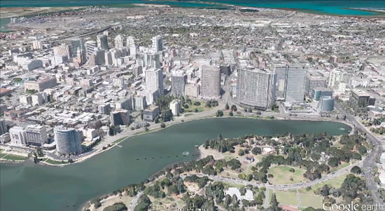
An important next step in improving all of these areas—comprehensiveness, accuracy and usability of our maps—is the ability to model the world in 3D. Since 2006, we’ve had textured 3D buildings in Google Earth, and today we are excited to announce that we will begin adding 3D models to entire metropolitan areas to Google Earth on mobile devices. This is possible thanks to a combination of our new imagery rendering techniques and computer vision that let us automatically create 3D cityscapes, complete with buildings, terrain and even landscaping, from 45-degree aerial imagery. By the end of the year we aim to have 3D coverage for metropolitan areas with a combined population of 300 million people.
I have been working on mapping technology most of my life. We’ve made more progress, more quickly as an industry than I ever imagined possible. And we expect innovation to speed up even more over the next few years. While we may never create the perfect map… we’re going to get much, much closer than we are today.
Posted by Brian McClendon, VP of Engineering, Google Maps
Since 2006, we’ve had textured 3D buildings in Google Earth, and we’re excited to announce that we’ll begin adding 3D models to entire metropolitan areas to Google Earth on mobile devices in the near future.
Thanks to new imagery rendering techniques and computer vision, we’re able to create 3D cityscapes, complete with buildings, terrain and even landscaping, from 45-degree aerial imagery.
By the end of the year, we aim to have 3D coverage for metropolitan areas with a combined population of 300 million people.
[iframe width=”550″ height=”309″ src=”http://www.youtube.com/embed/N6Douyfa7l8?rel=0″ frameborder=”0″ allowfullscreen]
Comments